
It’s common for summer to be Utah’s dry season. But 2025 took things to another level.
The main culprit was the missing monsoon — or as assistant state climatologist Jon Meyer designated it, a “non-soon.”
“I think that's the best word that we could use to describe most of our summer experience,” Meyer said. “The farther north you went, the more bleak it got.”
Salt Lake City received just 0.35 inches of rain from June 1 to Aug. 24 — putting it on pace for the city’s fourth driest summer on record. That included 48 straight days with zero precipitation at the airport during the peak of summer heat from early July to mid-August. That’s the city’s longest such streak since 1963, and its sixth longest on record.
Other Utah communities fared even worse.
By Aug. 24, Bountiful, Provo and Logan were all on track for their driest summers on record. Meteorological summer runs from June through August.
Increasingly hot summers with less reliable rainfall have become Utah’s new normal as fossil fuel emissions continue to drive global climate change. That has fueled drought expansion and intensification, leading to dangerous wildfire conditions and accelerated reservoir depletion across Utah this summer.
Some monsoon moisture finally broke through in the last week of August. Communities from Salt Lake City to St. George to Logan got more rain in that one week than they’d received the entire summer up to that point.
Still, it wasn’t nearly enough to claw Utah out of its summer deficit.
“Every drop counts at this point, so I'm not going to discredit the benefit” of that rain, Meyer said. “But in the general context of Utah's water resources — pun intended — this is kind of a drop in the bucket.”
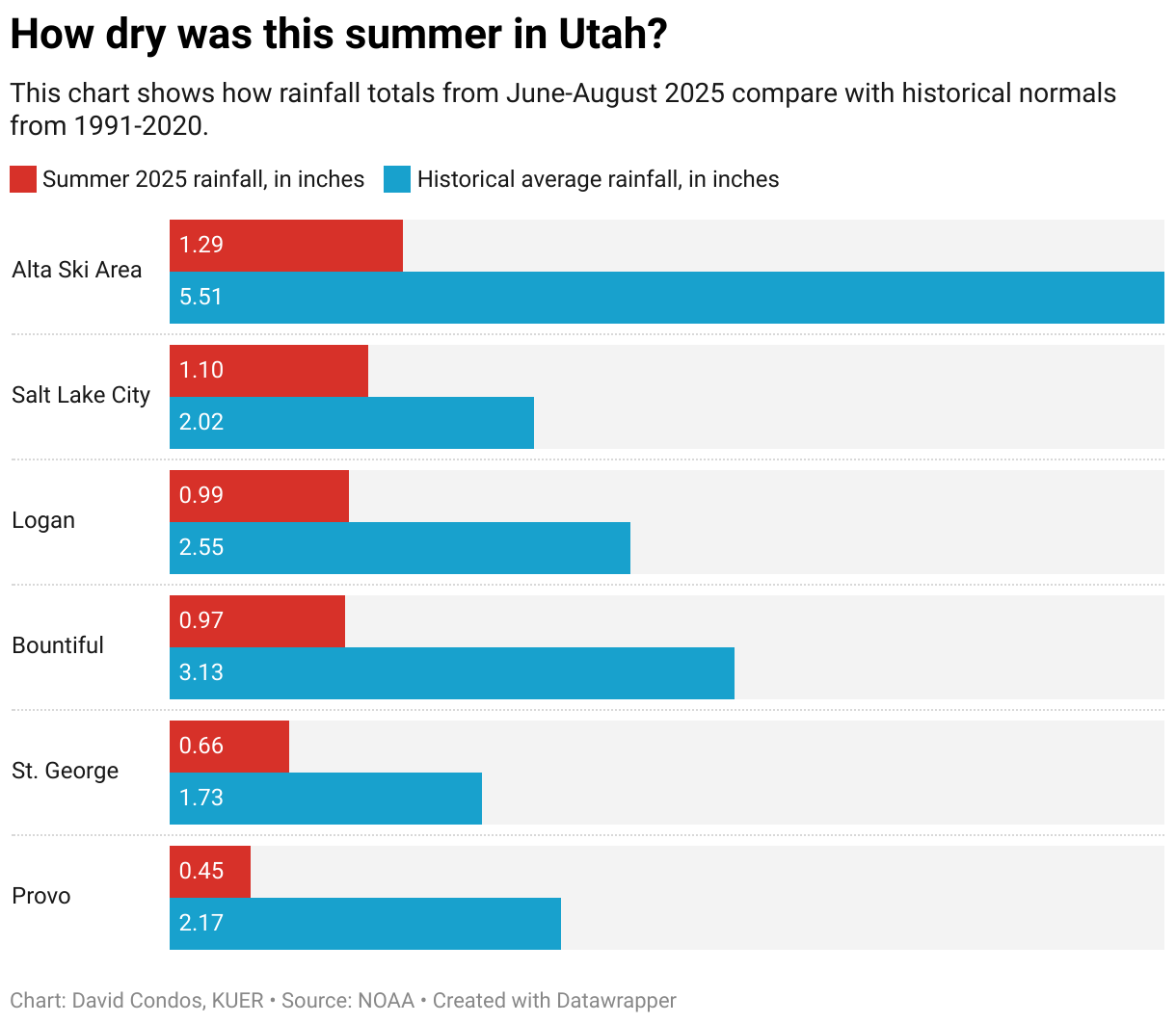
Salt Lake City ended up with 1.1 inches of rainfall from June to August. That’s around half of its historical average from 1991-2020 and low enough to make it the city’s 29th driest summer in records that date back to 1874.
Elsewhere, the late monsoon offered even less of a boost.
Provo ended the season with less than a half-inch of rain, its third driest summer on record. Alta Ski Area in Little Cottonwood Canyon also ended up having its third driest summer, with just 1.29 inches of rain. And despite more than quadrupling its summer rainfall total in the final days of the month, Bountiful still ended the season with just under an inch of rain, making 2025 the city’s sixth driest summer on record.
Ultimately, the late rains merely moved Utah from extremely dry to very dry, said National Weather Service senior meteorologist Monica Traphagan.
“It could have been a lot worse if we didn't get these couple of days,” she said. “But the fact remains that we've had an exceptionally dry remainder of the summer, so a week of wet certainly doesn't cancel out two, three months of very dry.”
Northern Utah is no stranger to missing out on monsoon moisture, Meyer said, because the rainstorms originate further south in the desert. This year stood out, however, because the region got virtually none of those timely downpours.
It came down to unfortunate geography, he said. The high pressure systems that power the desert storms were present, just too far east.
“There was a really nice monsoon season if you lived in New Mexico and Texas and eastern Colorado, but Arizona, Utah and western Colorado just missed out on event after event after event,” Meyer said. “This really highlights just how extremely variable the monsoon summer weather pattern can be.”
Even in southern Utah, where the monsoon was a bit stronger, St. George ended up with only 0.66 inches of rain for the season — far below its historical average of 1.73 inches. And more than half of the summer rain St. George received came in the final days of August.
The biggest way this summer’s storms helped Utah, Traphagan said, was by offering some temporary relief to the state’s dire wildfire conditions. When it comes to improving the long-term drought and water supply situation, however, monsoon rain plays a far smaller role than snow.
“All eyes will be on the winter,” Traphagan said. But “we don't anticipate, as we did a few years ago, busting the drought in one year with a record snowfall.”
The dry summer may already be stifling the impact of future snow by setting the stage for inefficient spring runoff. Even if the coming winter delivers average snowpack, Meyer said, the snowmelt would first need to replenish Utah’s depleted soil moisture before it gets the chance to run into rivers and recharge reservoirs.

The seasonal forecast for fall doesn’t offer much optimism, either. The National Oceanic and Atmospheric Administration’s outlook calls for above-average temperatures and below-average precipitation across the state through November.
“Utah’s sitting right in this bullseye of drier than normal and hotter than normal,” Meyer said. “That has been a trend that has been playing out more and more over the last few decades.”


