
It’s not too hard to see how dry western Utah is on the surface. Underground though, things are different — but changing. The hidden water supplies below are starting to dry up.
A multiyear study from the University of California, Santa Barbara collected data on global groundwater levels over the past few decades to paint a comprehensive picture of where supplies are declining and where they are stabilizing or refilling.
Several of the major aquifers in Utah’s Great Basin region fell into the study’s most dire category: Groundwater levels that were already declining before 2000 but saw accelerating declines between 2000 and 2022.
The research, recently published in the journal Nature, showed that 30% of the world’s aquifers belonged to that category. Scott Jasechko, one of the lead researchers, said those areas tended to fit the same mold — arid places with lots of irrigated cropland.
“I am not a naive optimist. There's a lot more places where things are bad than places where things are good,” the assistant professor of water resources at the Bren School of Environmental Science and Management said. “Utah, in a way, is a really nice microcosm of some of the global-scale trends we see.”
A couple of the state’s aquifers, Parowan Valley in Iron County and the Beryl-Enterprise area north of St. George, ranked among the worst in North America for accelerating rates of depletion from 2000 to 2022. Seven of Utah’s aquifers — all in the Basin and Range region between western Utah County and northern Washington County — ranked among the continent’s 50 fastest-declining aquifers during that time period. The study drew Utah’s data from the United States Geological Survey.
If this kind of depletion continues, Jasechko said, the consequences could endanger the homes, farms and cities that depend on the subterranean water supplies. Streams may begin to leak down into aquifers, reducing the availability of surface water. In some places, wells will run dry. For communities without many other sources to fall back on, that could threaten their access to clean, convenient drinking water.
While the study’s findings underscore the urgent need for action, he said, they also offer some hope from the communities that have found ways to slow or reverse their declines through policy changes that restrict water use and projects that bring in water from other sources.
“Groundwater is critically important for the daily lives of Americans. It's embedded in the food that we eat and the choices we make as consumers,” he said. “[But] groundwater depletion is not inevitable. There are ways to make things better, if we can come together and think about locally relevant solutions.”
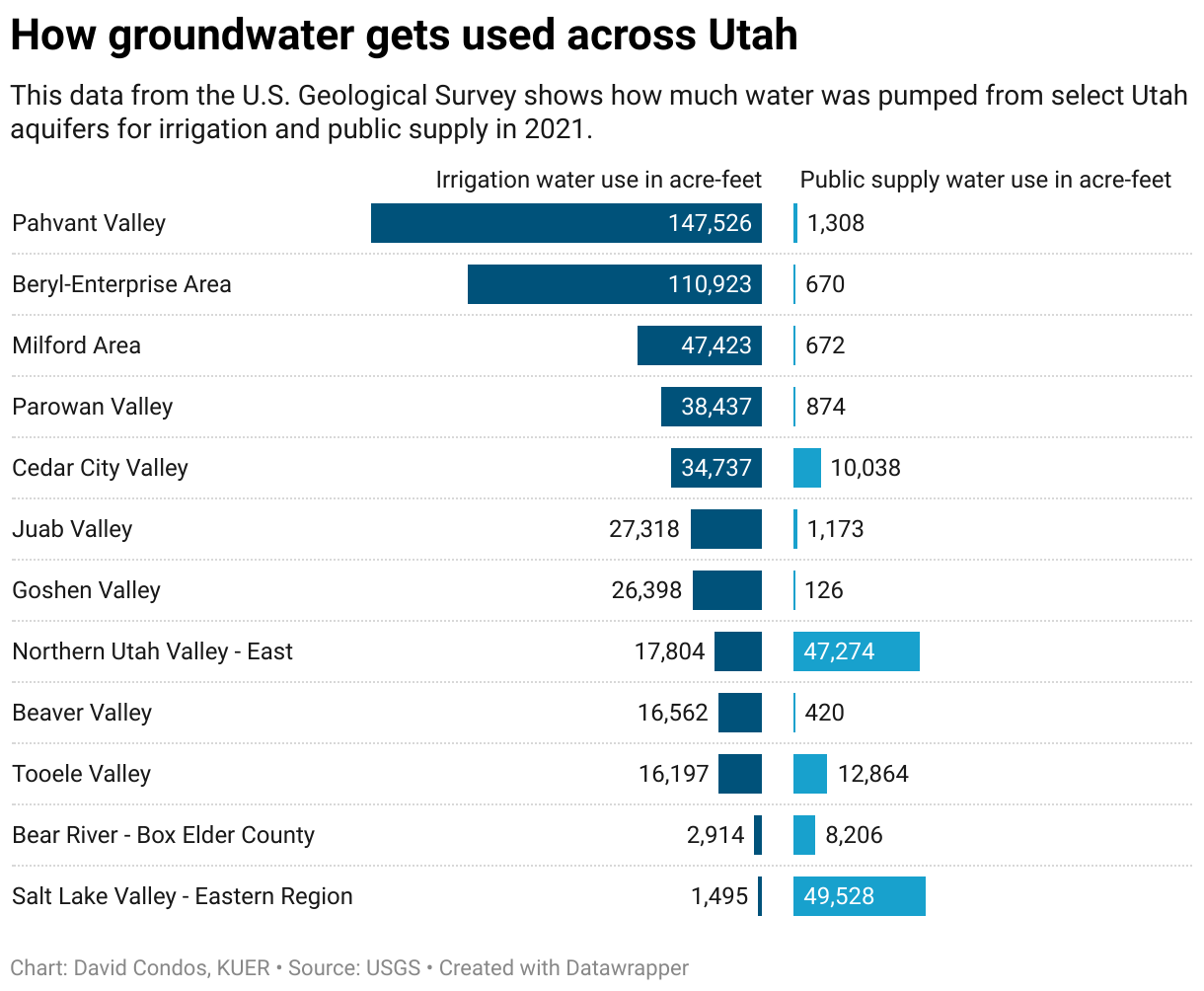
Overlaying this study’s findings with other data from the USGS confirms that Utah’s basins with accelerating groundwater declines are some of the same places pumping the most groundwater to irrigate crops. In the Beryl-Enterprise area, for instance, 110,923 acre-feet of groundwater were pumped up for irrigation in 2021 compared to just 670 acre-feet for public use. One acre-foot represents the amount of water that would fill one acre of land to a height of one foot.
Paul Inkenbrandt, a senior geologist with the Utah Geological Survey, saw some of these declines first-hand when he worked near Cedar City 15 years ago.
“We've seen aquifer groundwater level declines upwards of 100-feet-plus in Cedar City Valley [since the 1950s],” he said, “and coincident with that was ground subsidence and earth fissures.”
The water stored in the pores of underground rock helps hold up the skeleton of those geological layers, he said. So when water is pumped out, it weakens the rock and leads to fissures where the ground compacts and cracks — something that’s been happening around the Cedar City Valley for years. To make matters worse, he said, that compaction generally results in permanent loss of water storage space. So even if the aquifer could be recharged, it wouldn’t be able to hold as much water as it did before.
One of the other challenges is that scientists don’t know exactly how much usable water is left in these aquifers.
“It's hard to quantify that because as you go deeper, the hydrogeology can change,” Inkenbrandt said. “You can probably have water at thousands of feet down, but it's going to be different quality and quantity.”
Addressing this problem is complex, especially because each groundwater system is unique. For example, Jasechko’s study shows that groundwater levels in some other parts of Utah, such as the Heber Valley and Bear Lake Valley, remain relatively stable.
But Hugh Hurlow, a hydrogeologist who manages the groundwater and wetlands program with the Utah Geological Survey, said it’s fair to say that many of the aquifers in dry southwest Utah are not reaching that sort of equilibrium.
“Often, you don't get enough precipitation down there to really meaningfully recharge the aquifer,” he said. “So then if you continue to pump groundwater at the same rate, then you're kind of drawing from the bank account of the storage of the aquifer.“
What can Utah do about this? The first step, Hurlow said, is getting accurate, detailed data that shows how levels are changing so state and community leaders can base their decisions on that.
The U.S. Geological Survey has a network of wells statewide where it measures groundwater levels each March, he said, and some of those wells have been checked annually for more than a century. The Utah Geological Survey also measures some of the state’s aquifers, usually on a case-by-case basis for specific studies. The UGS plans to build its own statewide groundwater monitoring network this summer and launch an online database.
With that data, he said, leaders can create groundwater plans tailored to each area. For example, the Cedar City Valley adopted a plan in 2021 to begin gradually reducing how much water users can pump from the aquifer.
“We’re to the point where the state engineer is starting to design and impose groundwater management plans on the various basins as they see the trend of water levels continuing to decline rather than stabilizing,” Hurlow said. “So that's an indication that several basins are … trending quickly toward having reached their capacity.”
Jasechko’s study highlighted some groundwater success stories that might give Utah some solutions to consider.
Places like Bangkok, Thailand, and El Dorado, Arkansas, saw their aquifer levels rise after government action that restricted groundwater use or put high fees on pumping. Jasechko is cautious to say that policy change can slow or stop aquifer declines on its own — Bangkok and El Dorado have wetter climates than western Utah and alternative surface water sources are readily available.
Another potential solution is diverting water from somewhere else to reduce groundwater demand. The study showed this strategy has helped Albuquerque, New Mexico, reverse its aquifer declines since it began transferring water from the Colorado River Basin in 2008.
A third option is finding ways to boost aquifer recharge. The Avra Valley west of Tucson, Arizona, does this by directing water into ponds where it can trickle underground. Like the Albuquerque project, however, that water is pulled from the already-strained Colorado River system, which means it may not be sustainable or replicable for Utah.
“I think calling some of [these examples] ‘solutions’ is a little bit generous, especially when the Colorado River is the source of the water being diverted,” Jasechko said.
The best comparison to western Utah’s situation in this study, he said, might be Saudi Arabia’s Arab and Jubaila aquifers. After decades of steady depletion, the government began phasing out alfalfa farming there in 2016 and groundwater levels immediately started to rebound.
No matter how Utah approaches its groundwater declines, he said, putting an emphasis on locally created solutions is the key to reversing this depletion trend in a lasting way. At the very least, the few positive examples of aquifers refilling around the world show that it’s not a lost cause.
“What gives me hope is that there is evidence that things can be turned around,” Jasechko said. “This isn't unprecedented. There are places that have addressed groundwater depletion. They've come up with solutions that are locally relevant and, critically, implemented them”


